 |
| Tada! |
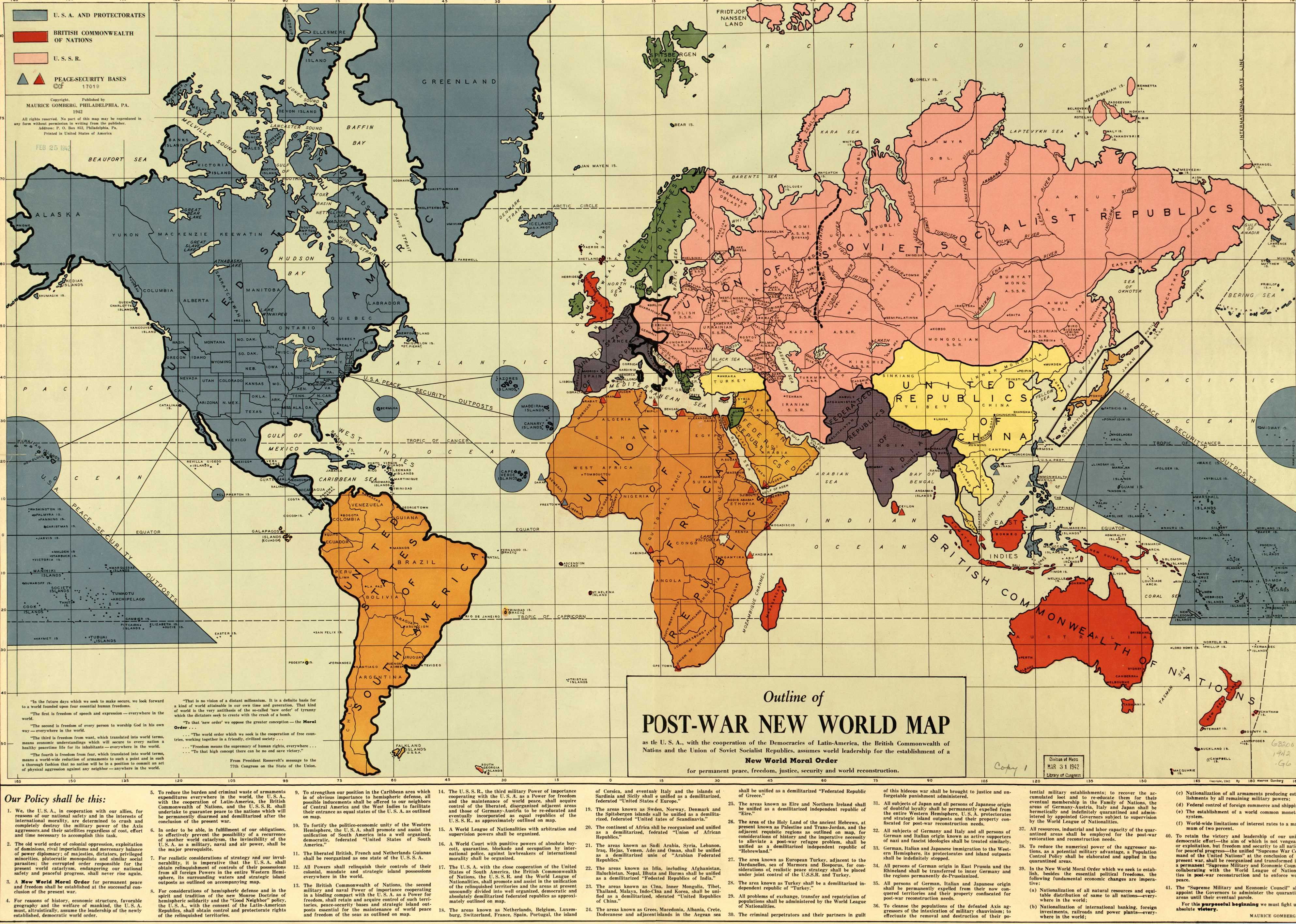
First: the United States of America, which has more than doubled in size to include Canada and Mexico and almost the entire Caribbean, an old Manifest Destiny ideal, as well as a lot of "USA Peace - Security Outposts" in the Atlantic and Pacific. These include most of the Azores (which was held by Portugal), Bermuda (which was a British Colony), Greenland and Iceland (both held by Denmark before the war) and many Islands that were held by France, Britain and Japan before the war in the Pacific. While many of these islands would be turned over to the US (Guam, Micronesia and the Marshal Islands), most are now independent or still under the control of their old Colonial masters for no better reason than they couldn't survive in the modern world without that help. Also included in the dark blue are Formosa (Taiwan), Mainan, and several island chains of Indonesia, presumably as part of the Philippines.
The other big country on the map is, of course, the Union of Soviet Socialist Republics, here stretching from the Rhine to Manchuria. Almost half of Europe, including a "Quarantined Germany" is part of the USSR, as well as all of Iran. If we looked at just Europe on this map, we could see the OTL border divisions that occurred, except with all of Germany, including Austria, being in the Soviet sphere of influence, and all being a direct part of the USSR. There are also a lot of other divisions of Russia within the USSR, either as Oblasts or "independent" Socialist Republics. I'm not sure what he meant here, if they are to be further administrative divisions or independent SSR's.
But the one thing that Gomberg loves (and is very much a failing of many a first time alternate history or futurist map maker) is continent spanning nations: the United States of Scandinavia, the United States of Europe (including Quarantined Italy), the United States of South America, the Union of African Republics, the Federated Republics of India (which includes Afghanistan), the Arabian Federated Republics, and the United Republics of China, which includes Indochina, Thailand and Malaya. Australia, New Zealand, the UK (minus Northern Ireland, surprisingly), Madagascar, Ceylon, most of Indonesia not taken over by the US, and New Guinea are part of the British Commonwealth of Nations, as well as small outposts in the Mediterranean and the Indian Ocean.
The Gomberg Map is, very much, an idealized view of what the world would look like, but also somewhat sinister: the fact that many countries that fought brutal wars to overthrow colonialists and unpopular, superpower backed leaders like Indochina/Vietnam, Iran, Afghanistan and Cuba are all just grouped in with the closest "big power" is very much a continuation of colonialist mindset, and very much a sign that Gomberg thinks that, only with massive, continent spanning nations like in South America and Africa can smaller nations experience peace. But, at the same time, Gomberg is very much a democrat: there are no true "Kingdoms" mentioned anywhere on the map: everything is a "Republic" or a "Commonwealth," or "United States of ___". Even today, when some of the most stable countries in the world are Constitutional Monarchies, and there are many dictatorships that claim they are Republics, this is a very noticeable distinction.
So, in the end, I personally think that the Gomberg Map, as a map for a true ideal of a post war world, is incredibly idealistic, but incredibly naive. I could already see the Union of African Republics tearing itself apart soon after the War when you have South Africa, which was on the verge of institutionalizing Apartheid, with many black African dominated colonies being thrust together into one nation with little experience and backwards economies and infrastructure. And having so many non Russians directly in the USSR would seriously upset the balance of power, which was a reason that Stalin prefered to set up puppet dictatorships in Eastern Europe instead of bringing them all into the Soviet Union. And I can't see the US willingly take all of South America and the Caribbean into the US: the old "banana republic" system of government served US interests much better than allowing dozens of islands and much, much weaker economies into the US, not to mention that Canada had spent decades (and still continues) to try to differentiate themselves from America to allow themselves to become part of the USA.
But what do you think? Is the Gomberg Map little more than idealism on paper, or could it have actually worked in real life? If you have a comment or a suggestion, leave a comment below, email me at tbguy1992@gmail.com or look for me on Twitter, @tbguy1992.
No comments:
Post a Comment